Tuesday, December 27, 2005

SE ~ Oaks Bottom


Date visited: December 16, 2005
Agency: Portland Parks & Recreation http://www.portlandonline.com/parks/?c=35300
Path Surface: Dirt, paved, gravel
Elevation gain/loss: Approximately 150 ft.
Distance: Two mile loop
Ratings: Setting +++ Calorie-burning ++
Directions: From SE Tacoma St, turn north on SE 7th to the parking lot at Sellwood Park.

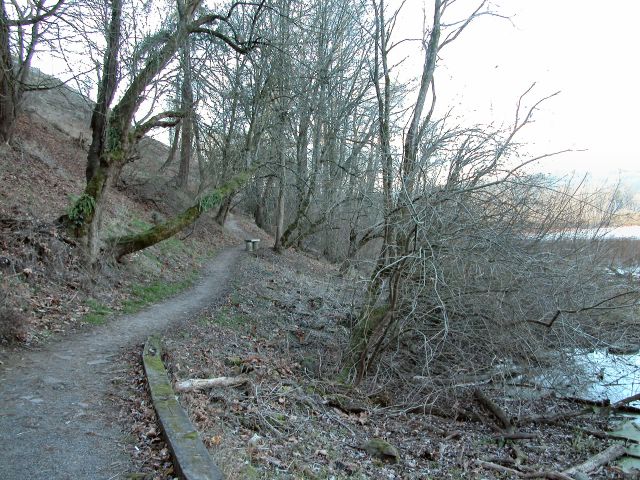
We are fortunate to have what is left of this Willamette River flood plain. Construction of the railroad tracks between the river and bottom lands was the first insult, compounded by garbage dumping and fill from freeway construction, the sum of which nearly obliterated what has become one of the premier preserves of Portland.

From the parking lot, zigzag down the bluff toward the water. Bufflehead and common mergansers dive and surface there. From force of habit, we normally continue along the bottom of the bluff (generally north), passing the wetlands on our left. We had ideal conditions for waterfowl observation today, as ice covered much of the shallow water, causing green wing teal, northern pintail, mallards and a few coots to congregate near the trail where the water was still liquid. Circling among these was a male and female wood duck and one lonely pied-billed grebe. While we watched, a first-year Cooper's Hawk tried without success to take a meal from the suddenly excited flock.

Continuing north along the path shows subtle changes to the vegetation as drier conditions prevail. At .8 mile, shortly after crossing a wooden bridge, turn left (west) on the dirt trail toward the Willamette, or continue just a bit farther north if you prefer pavement, again turning left toward the Willamette. After emerging from the woods, continue left (south) to go under the railroad tracks to the Springwater Corridor path. Step across the path (watch out for bikes) to see the "Shifting Assets" exhibit and get a good view of the river. To complete the loop, follow the paved Springwater Corridor south. Near the entrance to Oaks Amusement Park, the pavement splits. Veer right, downhill, to again pass under the tracks. Follow the gravel trail further south until it swings back to the bluff, turn left along the bluff trail and climb up to return to the parking lot.

A great place to look for birds any time of year--if you have your binoculars, this may the slowest two miles you have ever walked. Other birds on our list today included a downy woodpecker, black-capped chickadees, song sparrows, blue heron, a flicker, golden-crown sparrows, robins, a ruby-crowned kinglet, a brown creeper and a hermit thrush. (November 20, 2007 update to our bird species list: Anna's hummingbird, ring-neck ducks, lesser scaup, Stellar's and scrub jays, robin, flicker, juncos, northern shovelers, mallards, American goldfinch, American and Eurasian wigeon, gold-crowned kinglet, glaucous-winged gull, northern pintail, female golden eye, redwing blackbird, gadwall, ruddy duck, bald eagle, kingfisher, double crested cormorants, crow, hairy woodpecker, Bewick's wren, winter wren.)
Posted by Picasa

NW ~ Stewart Glen


Date visited: December 14, 2005
Agency: Vancouver-Clark Parks and Recreation
Path Surface: Paved
Elevation gain/loss: Gently rolling small hills
Distance: 3 miles round trip
Ratings: Setting ++++ Calorie-burning for Stewart Glen Portion ++
Directions: I-5 to 78th St. in Vancouver. Turn west 1.3 miles to Fruit Valley Rd. (Sign says Lakeshore Rd.) Turn left .4 mile, turn left onto Bernie Dr and immediately turn left into small gravel parking lot.

Take a pleasant walk along a tree-covered hillside overlooking the flood plain of Burnt Bridge Creek. Because of its proximity to Vancouver Lake, many waterfowl drift over to the pond at the beginning of this trail.

From the parking lot, walk down the railroad tie steps to the wide paved trail. Pause to enjoy the pond created by the back-up of Burnt Bridge Creek, where today widgeons, mallards, bufflehead, and gadwalls congregated in the small portion of the pond not covered by a thin sheen of ice. Turn right and enjoy the gentle roll of the path, watching out for some roots that have lifted the asphalt near the beginning of the trail. Alder and oak stand by. Occasional dirt paths shoot off from the main trail, permitting access to the water and to the upper hillside.

At .5 mile, cedars and doug fir crowd in. At .7 mile, the path emerges from the trees and meanders through the reed canary grass to meet up with the creek. Look for an old pear orchard. All too soon, the path ends at Hazel Dell Ave after crossing two other streets.

To continue, however, turn right on Hazel Dell Ave and walk .2 mile farther to pick up the path again on the east side of Hazel Dell Ave. (Look for the yellow posts in the path). This portion of the path will connect you to the Ellen Davis Trail and Discovery Trail on the east side of I-5, with opportunities for many more miles!
Posted by Picasa

Tuesday, December 13, 2005

SW ~ Tualatin Hills Nature Park


Date visited: November 24, 2005
Agency: THPRD
Path Surface: Pavement, boardwalk and dirt
Elevation gain/loss: minimal
Distance: Variable, but a 4+ mile loop is described below
Ratings: Setting +++ Calorie-burning ++
Directions: From Hwy 26, take the Murray Blvd exit, south on Murray 1.3 miles, west on Millikan Blvd .5 mile, parking lot on right as Millikan curves to the south. Address: 15655 SW Millikan Blvd. Information: (503) 629-6350

This 219 acres used to be just an anomaly of suburbia without organization, facilities or human amenities. I often walked my dogs through the area on narrow dirt trails without seeing another soul. Now that the park has been "improved," dogs are prohibited and it is much more difficult to get that "middle-of-the-forest" feeling because of the popularity of the park. Ah, progress....

Nonetheless, an enjoyable walk is possible here. If you can find a quiet moment, you might be surprised by what you see and hear in the park. Try to block the background noise to listen for the descending call of a downy woodpecker or the buzzy sounds of a towhee or a Bewick's wren. Larger animals also make an occasional appearance.

From the parking lot, pick up a trail map and stroll past the Interpretive Center into the trees on the paved trail. Veer right onto the Oak Trail, which skirts the marshy wildlife preserve through oak, alder and water loving plants. No human trails enter the preserve, with the idea of keeping the area as natural as possible (considering it is smack dab in the middle of Beaverton). For all the natural setting, though, traffic noise from the surrounding area unfortunately seeps through the trees in winter.

After .5 mile, and passing through one of the healthiest stands of horsetails I have ever seen, turn left on the unpaved Creek Trail. This trail roughly follows the course of Cedar Mill Creek, but the water is rarely visible. You may, however, see groups of kinglets and chickadees. After walking just over .3, veer right at the Old Wagon Trail. Stay on this trail, ignoring the junction at the Coyote Trail. At the intersection with the Vine Maple trail, turn left and take the short detour to the Lily Pond. We saw three deer here today, one about 10 feet away.
.
Continue on the Vine Maple Trail .4 mile and turn right on the Elliot Trail. Follow it .1 mile to the Big Fir Trail, which travels through the most mature forest area in the park, across Beaverton Creek and into the West Woods. Make the .7 mile loop of the Cougar, Chickadee, Cedar Grove, Ash and Service Berry Trails. Cross back over Beaverton Creek, return on the Big Fir Trail, and detour on the Trillium Loop Trail by veering right onto the Beaver Trail. Take a look at the Big Pond, a waterfowl hangout in the winter

After returning back to the Big Fir Trail, turn right .1 mile to the Ponderosa Trail. The Ponderosa Trail goes through the South Woods, the newest part of the park, to meet back up with the Vine Maple trail. Turn right to return to the parking lot .2 mile away, for a 4.1 mile total trip. Posted by Picasa