Date last visited: May 27, 2005
Distance: 5 miles one way with shuttle
Ratings: Setting +++ Calorie-burning + + (or more depending on how much you paddle)
Directions: To Rood Bridge Park in Hillsboro, from Farmington Rd. west of Beaverton, turn right on River Road, north 3.4 miles, left on Rood Bridge Rd to Rood Bridge Park. (Rood Bridge Rd. is also 1.1 miles south on River Road from Tualatin Valley Hwy.) GPS N 45.29.39 W 122.57.08. Boat launch is toward south end of park. To take-out point at Harris Bridge: from Farmington Rd and River Rd intersection, drive west one tenth mile to Harris Bridge (the bridge is currently under construction, to reopen in November of 2005). GPS N 45.26.97 W 122.57.06 WARNING: DO NOT ATTEMPT this unless you can get in and out of your boat without being on land. At two places in our route, fallen trees have completely blocked the river at water level and the banks are too steep to portage. We had to crawl out of our kayak onto the logs and drag it over, then hop back in on the other side.
Memorial Day Weekend of 2005 may be remembered by the big tease. Just prior to the weekend, it felt like mid-summer, with temperatures into the 90's, but the weekend was only average (at least it didn't rain). When the temperatures climb, though, it's time to take to the water!
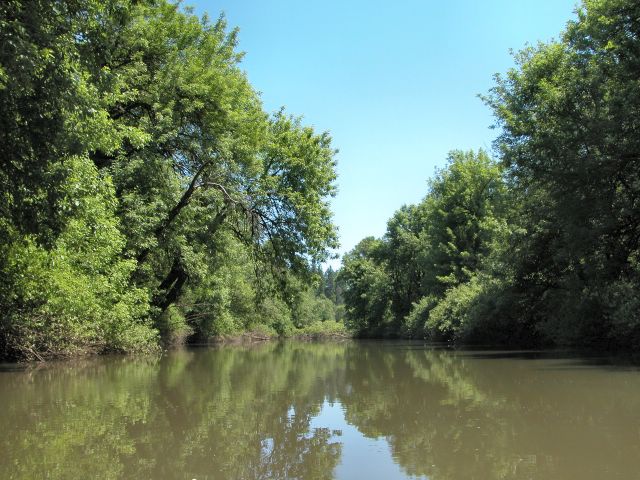
This tree-lined, snaking section of the Tualatin River is perfect for a quick afternoon paddle. We left a bicycle chained to Harris Bridge and drove to Rood Bridge Park to launch. The river is easy to access from the boat launch, although don't wear your best sneakers unless you want to leave them in the mud. Birds twitter and flutter overhead in the trees, with swallows occasionally swooping by. We startled a female wood duck with several chicks and finally had to stop for a few minutes to prevent disturbing them too much as they made their way down river.
The river's current will carry you along at about 1.5 miles an hour without paddling, but if you want some exercise, dip in. This stretch of the river is relatively quiet and you'll see few structures and fewer people. Just after crossing under Harris Bridge, on the east bank, is a wooden rail that will help you out of your boat and up the muddy, slippery shore. The climb back up to road level with your equipment is rough, but doable. Take a look when you set up your shuttle to determine whether it is within your capabilities.
Several other public access points, including some new ones, allow for a longer trip, if you so desire.


No comments:
Post a Comment