Here's a resource that I just discovered for trails in the West Linn area. I haven't been on any of these trails except some in Mary S. Young park, but as I get there, I will post reviews.
Trail Maps for the City of West Linn
Showing posts with label walking. Show all posts
Showing posts with label walking. Show all posts
Thursday, May 29, 2014
Friday, January 25, 2013
SW ~ Magness Memorial Tree Farm

Date visited: January 21, 2013
Agency: World Forestry Center
Path Surface: Paved loop and dirt
Elevation gain/loss: Unknown, but several steep sections on the trail in the northwest part of the property
Distance: Variable depending on the route. Several trails and length options. See map and description below.
Ratings: Setting ++++ Calorie-burning ++++ when hiking in the northwest portion of the park
Directions: 31195 SW Ladd Hill Rd, Sherwood, OR. From I-5, take Wilsonville exit 283, turn right on Wilsonville Rd. After 4.1 miles, turn right on Edminston Rd. for 1.3 miles, then right on Ladd Hill Rd. The gated parking lot is on the left.
We did not have high expectations for this site but we were pleasantly surprised. On this cold winter day, we hiked for several miles all by ourselves and enjoyed the bird variety we saw. Of course, it helped that it was a bright sunny day....
From the parking lot, we walked on the paved Nagel Trail to take a look at the rental cabins, but when we crossed the creek on the bridge, we felt like we were really out in the woods. We stayed on the pavement for awhile, enjoying a large group of ruby-crowned kinglets near the springs, but then we started wandering.
We didn't have a site map with us and what appeared to be a map brochure on-site was frozen to its box. Reviewing the map linked below, I can reconstruct that we left the pavement and walked the footpath to near Corral Creek Rd, then followed the path north. We took the loop detour in the northwest section of the property, where we gained quite a bit of elevation. I did not have my GPS with us to get an elevation reading so that will require another trip.

Our route took us slightly more than 4 miles.
Map of the trails on the property.
Tuesday, August 14, 2012
SW ~ Tryon Creek State Park - Summer

The Terry Riley suspension bridge
Date visited: August 14, 2012Agency: Oregon State Parks and Recreation Dept.
Path Surface: Dirt, gravel. All-accessible trail and bike path are paved.
Elevation gain/loss: Variable, but there's some short steep hills on some of the trails.
Distance: Variable depending on the route. Several trails and length options.
Ratings: Setting ++++ Calorie-burning ++++ for perimeter of the park route
Directions: From I-5, take the Terwilliger Blvd exit and go 2.3 miles south to the park entrance.
The weather is warmer, the trails are dustier and it's almost five years since our last report on Tryon Creek State Park. Today, we reversed our route from that visit. Many more people were using the trails, and we had to walk a quarter of a mile before birdsong could be heard over the excited voices of many children in the vicinity of the Nature Center. Nevertheless, we spent several lengthy periods of solitude and almost-quiet.
A few wildflowers remain, but mostly green and brown are the colors of the day. Pick your trails and enjoy!
Monday, March 12, 2012
SW ~ Graham Oaks Nature Park

Date visited: March 7, 2012
Path Surface: Asphalt, gravel
Elevation gain/loss: +/- 10 feet
Distance: 3+ miles
Ratings: Setting + Calorie-burning ++
Directions: From I-5, take exit 283 (Wilsonville Rd), go west about 1.5 miles to the small parking area north of the road.
Agency: Metro
Restoration has to start somewhere, but it is a stretch to call this a nature park now. Houses and a school crowd the edges of the park. Only one small portion of a path passes through trees of any size. But if you are in need of an wide open view and a short walk with plenty of company, Graham Oaks will work for you.
A paved path, the Tonquin Trail, slices through the middle of the park, and unlike other Metro properties, dogs are allowed on the pavement. Trails of varying lengths branch from the pavement. One, the Arrowhead Creek trail, will be the most interesting to spring and fall birders (although the best area we found was outside the park). In winter, the small pond seen from the Wetlands Overlook will attract some waterfowl. The Legacy Creek trail passes through a typical west side forest, and on our walk, osoberry, nettles and wild rose were just beginning to show green leaves. The creek itself whispers out of sight in a nearby gully.
Many small trees have been planted and it will be fun to share your pictures of the park with your grandchildren in 50 years, when some of those trees return an agricultural field to a forest.
Posts at trail junctions show maps.
Friday, April 29, 2011
SW ~ Cooper Mountain Nature Park

Sometimes our springs are inexplicably similar to our winters, but weather can make our familiar places new again.
See the full description here.
Tuesday, February 22, 2011
NW ~ Banks Vernonia Trail-Banks to LL Stub Stewart Park

Date visited: February 19, 2011
Path Surface: Asphalt
Elevation gain/loss: Variable. 250 feet as described below.
Distance: Up to 21 miles one way
Ratings: Setting ++++ Calorie-burning ++++
Directions: Choose from several trailheads. We have gone to the Manning trailhead for so long we naturally gravitate there. If you've driven to the coast on Hwy 26, you've seen the sign for the turn off, just west of Banks.
Next time we will try the recently-opened Banks trailhead because there is more parking. Page 2 of this pdf brochure has a map of the trail and trailheads.
Sunshine in February seems more valuable than in, say, August and that got us out of the house and onto our bikes last Saturday. But really, sunny or rainy, this trail is a great place to get some exercise. Although we were on bikes today, many people were walking the trail.
We've been coming here for years, biking the various sections of the trail as they were completed. Today, we rode from the Manning trailhead northwest to the entrance road of Stub Stewart Park. This section includes crossing the Buxton trestle, an unusual thrill on a bike. We also rode to Banks to check out the new trailhead there, a big improvement from the abrupt end to the trail formerly in place.
From Banks, the trail has little elevation change, which continues as you pass the Manning trailhead. At about mile 5, the trail becomes a gentle but steady climb which doesn't quit as far as we rode. The surroundings likewise change from pasture to woods. We stopped several times to enjoy the scenery and the climb kept us warm in spite of a trail side skiff of snow in some shady spots.
We'll be checking out other sections of the trail in the future to see what changes have been made since our last visits to those sections several years ago.
Wednesday, January 05, 2011
SW ~ More Tualatin

Date visited: December 9, 2008, January 4, 2011, January 14, 2011
Path Surface: Pea gravel trail, concrete, asphalt
Elevation gain/loss: none
Distance: .8 mile one way
Ratings: Setting ++ Calorie-burning +
Directions: Extension to Tigard-Tualatin route to get adequate mileage. From Tualatin Community Park, head west for one long block on Tualatin Road to Sweek Dr. Path behind Tualatin Heritage Center, 8700 SW Sweek Drive in Tualatin.
A nice extension to a previous post trail is the short loop around Sweek Pond and the views over the Hedges Creek Wetlands. Sweek Pond is an old man-made seasonal pond behind the Tualatin Heritage Center. We were told that there are resident wood ducks--we didn't see them today--but we did see a few other birds and the walk is pleasant. [We finally saw wood ducks in this pond on our 1/14 visit, along with a male and three female hooded mergansers.]
At the end of the pond loop, turn right on the sidewalk, continue over the wooden bridge spanning Hedges Creek. Take a look here, but we actually saw much more bird life ahead. Walk to the end of the path (Starbucks ahead) and turn right in the driveway behind the shopping center. Follow the driveway to the road and turn right toward 90th Ave. Walk along 90th Ave to a bridge over the wetlands. We saw waterfowl, shorebirds, heron and egrets right from the sidewalk. In January of 2011, we saw tundra swans in the distance from the bridge.
Continue on 90th Ave and turn right on Sweek Drive to return to the Heritage Center.
Monday, November 29, 2010
SE ~ Powell Butte

Date visited: November 10, 2010
Agency: Portland Parks and Recreation
Path Surface: Some pavement, but mostly dirt
Elevation gain/loss: 300 ft
Distance: Variable and can include mileage on the Springwater Corridor.
Ratings: Setting +++ Calorie-burning ++++
Directions: East on Powell Blvd to 162nd Ave. Turn right and drive up the hill to a parking area.
On a clear day, not many places can beat the views at Powell Butte. Even on a cloudy day, little windows of opportunity can open. When we first got out of the car, we could see sunbeams on the snow-dusted foothills across the river in Washington. And it's a good place to see a microcosm of northwest Oregon, even on the wet weather days, in the open meadows and forested trails of this park.
The worst thing about Powell Butte is how easy it is to get lost; well, not lost really, but momentarily displaced. Some trails are marked, some trails are a mystery. We had two maps with us, neither of which was entirely accurate. One is shown here, but we had to backtrack on the Elderberry Trail to find our way to the outer loop of the park (or maybe we just can't read a map!) We ended up walking around 5 miles because of our backtracking, but anyone into higher miles can simply drop down to the Springwater Corridor.
I ate a late season blackberry which tasted like thick water, and we noticed some stinging nettle, especially on the south side of the park. But there's plenty of opportunity for bird life.
 Today our bird list included: song sparrows, mourning doves, flickers, three kestrels visible at once, crows, Bewick's and Pacific Wren, Stellar's jay, spotted towhee, a screeching red tail hawk, varied thrush, scrub jay, juncos, golden-crowned kinglets, and finally, a northern harrier cruising the area east of the Orchard Loop Trail.
Wednesday, November 17, 2010
NW ~ Wildwood Trail from Germantown Rd Loop

Date visited: November 8, 2010
Agency: City of Portland Parks and Recreation
Path Surface: Dirt and mud
Elevation gain/loss: 300 feet
Distance: Variable, we went about 5 miles
Ratings: Setting ++++ Calorie-burning ++++
Directions:Germantown Road is between US Highway (the road to St Helens) and Skyline Boulevard. The Wildwood Trail parking is at N 45 35.236, W 122 47.640. The slightly larger parking lot at Leif Erickson Drive is at N 45 35.345, W 122 47.423.
We started out with the hike described in Afoot & Afield Portland/Vancouver: A Comprehensive Hiking Guide
On our hike today, huge golden leaves from the maples zig zagged through the air giving up to gravity and the season. Leaves lined the trails and have already turned to trail mush in the middle of the path.
We chose to go on another quarter mile or so to the Hardesty Trail to form the bottom of our loop. Also, while the book describes a walk back to your car on Germantown Rd, there is now a trail, the Cannon Trail from Leif Erickson back up to the Wildwood trailhead. A map is available here, although it does not show the new Cannon Trail, which parallels Germantown Rd.
If you want to see pileated woodpeckers, this is prime territory. Not far into the hike we heard two, sounding like native tribes signaling each other. Woodpecker sign was all around us. When we had dropped down to Leif Erickson Dr, we finally saw one: the large wingbeats caught my attention. Many other forest birds were active throughout our walk today.
Next time, I think we will start on Leif Erickson. A bigger parking lot and we'll end with a downhill walk instead of a final uphill ascent to the car!
Friday, November 05, 2010
SW ~ Camassia Natural Area

Date visited: November 5, 2010
Agency: The Nature Conservancy
Path Surface: Dirt, boardwalk, rock
Elevation gain/loss: 20 feet
Distance: loop trail, .6, possibly a mile with all extensions
Ratings: Setting ++ Calorie-burning +
Directions: From I-205, take exit 8, West Linn, turn south toward Oregon City. Quickly look for Willamette Falls Road and turn right (just before the gas station). Veer right in a quarter mile at Sunset Ave. Take the first right onto Walnut Street. Drive to the end to the small parking area. GPS N 45.35922, W 122.61824.
Notes: NO PETS ARE ALLOWED.
I can't really recommend this area for exercise. We visited today, realizing that fall is not the area's best season. In the void created by the absence of the famous camas flowers, however, we noticed the variety of trees in this tiny preserve. I'll put it on the list for spring. And we'll try to figure out how to get some mileage out of this.
Saturday, October 23, 2010
SW ~ Cooper Mountain Nature Park 2010

Date visited: October 20, 2010
Agency: Metro/ THPRD
Path Surface: Mostly gravel
Elevation gain/loss: 330 feet
Distance: 2.9 miles as described, 3.5 miles of trails
Ratings: Setting ++++ Calorie-burning ++++
Directions: From Highway 217, take the Scholls Ferry Road exit and go west on Scholls Ferry. At Southwest 175th Avenue, turn right and go north, uphill, about 1.8 miles. Curve left on Kemmer Road. The park entrance is on the south side of Kemmer Road near its intersection with 190th. Or, from Southwest Farmington Road (Highway 10), turn south on 185th Avenue, which will become Gassner Road, turn left on 190th Avenue and left on Kemmer Road. NO PETS ARE ALLOWED.
Orange spray paint? Nope, that really is the color of the trees. Many more trees are decked out in their fall colors and are only slightly less dazzingly against the blue sky (likely one of the last for this autumn).
We originally described this site here following our July 2009 visit. It was much more "birdy" that day. Today's visit was quiet and mid-day. We saw robins, black-capped chickadees, scrub jays, song sparrows, Bewick's wrens, crows, juncos and heard a flicker and a couple of towhees. The best bird moments, however, were seeing both a ruby-crowned and golden-crowned kinglets.

The poison oak present on our original visit has only multiplied, turning a beautiful shade of red now, but just as poisonous!

There's a trail guide at the top, but you don't need to memorize it. Posts at every junction tell you where you are.
Wednesday, October 06, 2010
NE ~ Oxbow Park

Date visited: September 24, 2010
Agency: Metro
Path Surface: Dirt
Elevation gain/loss: 105 feet
Distance: 3.7 miles as we did it
Ratings: Setting ++++ Calorie-burning +++
Directions: From Interstate 84 east of Portland, take the Wood Village exit, left on Division and follow the signs.
Additional Information: $5 entrance fee and because this is a Metro park, NO DOGS are allowed.
We saw no ox, but two deer grazed on the brush right inside the entrance to this surprisingly quiet park on our early autumn visit. You might find, as we did, that the trails are nearly deserted.

East of Portland, the Sandy River makes two big U-shaped bends in an "oxbow." One circles Camp Collins and another loops around the campground and hiking trails of Oxbow Park. What this means for hikers is that you can do a loop trail and be next to the river much of the way.
On our easy hike today, the last few straggling turkey vultures of the season float lazily by. A few female common mergansers paddle in the river. Winter wren and Stellar's Jays compete for bird of the day. While there were a few people fishing and a few hearty souls in the campground, we saw only two other people on the trail today, and those were both working on trail maintenance. The lack of traffic was further emphasized by the number of spider trails I took full in the face.
A nice route through the park is described in 100 Hikes in Northwest Oregon & Southwest Washington, 3rd Edition
Wednesday, September 29, 2010
SW ~ Tualatin Hills Nature Park

Date visited: September 22, 2010
Agency: THPRD
Path Surface: Pavement, boardwalk and dirt
Elevation gain/loss: minimal
Distance: Variable, but a 4+ mile loop is described below
Ratings: Setting +++ Calorie-burning ++
Directions: From Hwy 26, take the Murray Blvd exit, south on Murray 1.3 miles, west on Millikan Blvd .5 mile, parking lot on right as Millikan curves to the south. Address: 15655 SW Millikan Blvd. Information: (503) 629-6350
This 219 acres used to be just an anomaly of suburbia without organization, facilities or human amenities. I often walked my dogs through the area on narrow dirt trails without seeing another soul. Now that the park has been "improved," dogs are prohibited and it is much more difficult to get that "middle-of-the-forest" feeling because of the popularity of the park. Ah, progress....
Nonetheless, an enjoyable walk is possible here. If you can find a quiet moment, you might be surprised by what you see and hear in the park. Try to block the background noise to listen for the descending call of a downy woodpecker or the buzzy sounds of a towhee or a Bewick's wren. Larger animals also make an occasional appearance, like the deer we saw on this visit.
From the parking lot, pick up a trail map and stroll past the Interpretive Center into the trees on the paved trail. Veer right onto the Oak Trail, which skirts the marshy wildlife preserve through oak, alder and water loving plants. No human trails enter the preserve, with the idea of keeping the area as natural as possible (considering it is smack dab in the middle of Beaverton). For all the natural setting, though, traffic noise from the surrounding area unfortunately seeps through the trees in winter.
After .5 mile, and passing through one of the healthiest stands of horsetails I have ever seen, turn left on the unpaved Creek Trail. This trail roughly follows the course of Cedar Mill Creek, but the water is rarely visible. You may, however, see groups of kinglets and chickadees. After walking just over .3, veer right at the Old Wagon Trail. Stay on this trail, ignoring the junction at the Coyote Trail. At the intersection with the Vine Maple trail, turn left and take the short detour to the Lily Pond. We saw three deer here on another trip, one about 10 feet away.
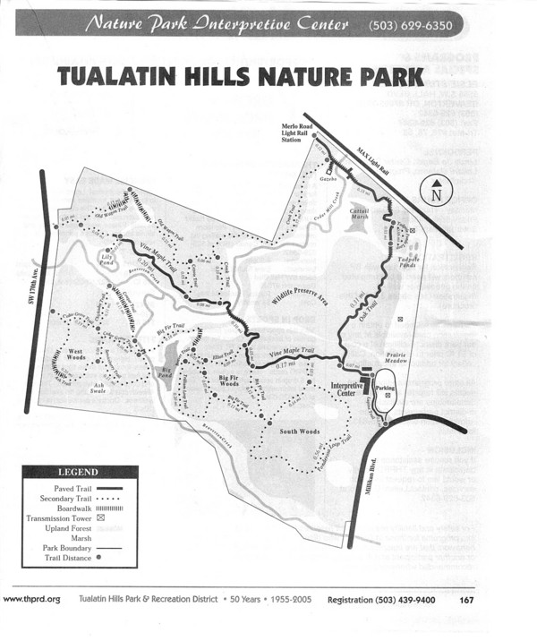
Continue on the Vine Maple Trail .4 mile and turn right on the Elliot Trail. Follow it .1 mile to the Big Fir Trail, which travels through the most mature forest area in the park, across Beaverton Creek and into the West Woods. Make the .7 mile loop of the Cougar, Chickadee, Cedar Grove, Ash and Service Berry Trails. Cross back over Beaverton Creek, return on the Big Fir Trail, and detour on the Trillium Loop Trail by veering right onto the Beaver Trail. Take a look at the Big Pond, a waterfowl hangout in the winter
After returning back to the Big Fir Trail, turn right .1 mile to the Ponderosa Trail. The Ponderosa Trail goes through the South Woods, the newest part of the park, to meet back up with the Vine Maple trail. Turn right to return to the parking lot .2 mile away, for a 4.1 mile total trip.

Thursday, August 19, 2010
SW ~ Summerlake Park

Date visited: March 12, 2007, last update August 19, 2010
Agency: City of Tigard
Path Surface: Asphalt, dirt, concrete
Elevation gain/loss: 20 ft.
Distance: 1.2 as described
Ratings: Setting +++ Calorie-burning +
Directions: From Highway 217, follow Scholls Ferry Rd southeast to SW 130th and turn left. Curve around to the left as 130th Ave. changes to Winterlake Drive. Look for the parking lot on the left about .5 mile from Scholls Ferry Rd and thirty yards past the picnic shelter. GPS N 45 26.191, W 122 48.627.
Map of the park.
Summer Creek seems to appear from nowhere in this densely developed residential area, but then backs up to form several open water ponds. Two are surrounded by a paved path, and a third can be reached by a short spur. This tiny oasis in thick suburbia holds an amazing variety of wildlife.
From the parking lot, walk north along a path that heads into a small douglas fir, cedar and deciduous forest. Note the Sorg Rhododendron Garden to your right just before you get to the clustered trees. Cross over a little trickle of water into the grove. Several dirt trails take off to the right from the main path; some offer a lake view. Perching birds love the brushy vegetation along the path on either side of the evergreens. We saw bushtits, song sparrows and towhees jumping through the branches and a flock of gold-crowned sparrows searching for food in the woodsy debris along the path.
As the trees thin and after crossing a bridge over Summer Creek, take a short detour left, carefully crossing 130th Ave. to take a look at the wetlands area to the west. Today we saw several green-wing teals, but sometimes you might spot the very colorful wood ducks here. Return to the park and continue east along the “top” of the lake. Canada geese, white-fronted geese and some interesting hybrids hang out along the grassy areas. We saw a pied-billed grebe in the water, many widgeons and even more mallards. Several nutria haunted the shore and “v”ed their way through the water.
We find the first turn to the right irresistable because of the view from the bridge, so go ahead and turn south, across the bridge toward the playground area. You will return to this bridge as the middle of the figure 8 of this walk. Turn left and continue along the south edge of the lake, passing the playground on your right. Robins, flickers and crows seem to favor this area. Red-wing blackbirds perch overlooking the water. Later on in the season, barn swallows will cruise right by you as you walk the path.
Just before coming to another bridge at the east end of the park, take the short spur path to your right, noting the abundant perching birds in the trees here, then turn left on another path at a fence, toward the water. After taking a peek at the waterfowl (binoculars are good here), back track to the main path and turn right to cross another bridge—again an interesting place to stop for a look. Continue around the circle to head west, turn left to cross the bridge you previously crossed near the playground, but this time turn right after crossing the bridge. Walk briefly down hill, ignore the left turn here and walk straight over a small bridge back into the big trees. Follow the dirt trail to its end at an asphalt driveway for the maintenance building. Walk straight through the rhodie garden or stroll the gravel paths through the garden in the spring for a colorful show.
In August, it's fun to take a look at the babies that have turned into miniature adults. We have seen young mallards, wood ducks, grebes and robins who seem more friendly than their wiser adult counterparts.
To get some additional mileage, you can walk the perimeter sidewalks or simply walk through the adjacent neighborhood to the south of the park.
To get some additional mileage, you can walk the perimeter sidewalks or simply walk through the adjacent neighborhood to the south of the park.
Wednesday, August 26, 2009
NE ~ Gibbons Creek Wildlife Trail

Date visited: July 28, 2009
Agency: US Fish & Wildlife
Path Surface: Gravel
Elevation gain/loss: Minimal
Distance: 2.25 miles
Ratings: Setting +++ Calorie-burning ++ to ++++
Directions: Entrance is east of Washougal on Highway 14. Look for the signs.
On a very hot day, we explored this new trail through Steigerwald Lake NWR. The path begins through open fields, crosses a tree-lined bridge, then parallels a dike on the right. On a clear day, Crown Point is visible across the Columbia River.
One lonely killdeer patrolled what little moisture remained in a small pond near the parking area. Common yellowthroats and savannah sparrows hid in the grassy fields.
Closer to the river, strips of cottonwood trees begin and bird life picks up. We saw dozens of goldfinches along with a respectable number of other species, including, to my surprise, a white breasted nuthatch without an oak in sight.
At an intersection, a sturdy bridge crosses Gibbons Creek and the path passes Redtail Lake, where even in the heat of this day, we could see a tundra swan and several mallards enjoying the water. We followed the path to its connection to the Washougal Dike Trail, where you can add several more miles to your walk.
We did not try the seasonal trail along Gibbons Creek--it was just too hot! It looks like a nice loop could be made by following the seasonal trail to the Columbia River Overlook, then turning west on the Washougal Dike Trail to rejoin the Gibbons Creek Trail at the Redtail Lake Overlook.

Monday, August 17, 2009
SW ~ West Side Regional Trail-THNP to Davis

Date visited: July 28, 2009
Agency: Tualatin Hills Parks & Rec
Path Surface: Asphalt
Elevation gain/loss: 100 feet
Distance: Six miles (out and back)
Ratings: Setting +++ Calorie-burning ++++
Directions: From Hwy 26, take the Murray Blvd exit, south on Murray 1.3 miles, west on Millikan Blvd .5 mile, parking lot on right as Millikan curves to the south. Address: 15655 SW Millikan Blvd. Information: (503) 629-6350.
Begin from the Tualatin Hills Nature Park. From the parking lot, enter the park passing the interpretive center on the paved path and veer right onto the Oak Trail. While on this forested path, listen for the happy song of the winter wren, while towhees, song sparrows and purple finches join in.
Go .4 mile to the gravel Tadpole Pond Trail. (If you are riding a bike, walk it on this short section.) As you pass the pond, turn right onto a paved bike path. After almost .9 mile, cross Millikan Blvd and continue on the path, scanning for red tailed hawks perched on the powerline towers. The path curves back to Millikan, where you must turn left onto the sidewalk to rejoin the path after crossing over the bottomlands of Beaverton Creek. Notice the nest boxes here. Tree swallows were swarming this area today.
Continue .2 miles farther on the path to the corner of TV Highway and Millikan Blvd. After crossing TV Highway, Millikan becomes 160th . Follow 160th just over a tenth of a mile to Blanton and turn left. Another tenth of a mile connects you back to the path on your right. The .4 mile stretch to Farmington Rd. is shrubby and nearly level, and on this morning, filled with blackberry pickers.
Cross Farmington to reconnect with the path, which is nearly level until you reach Division. From here, the path switchbacks up into Schuepbach Park, drops down, then zigzags up to Davis Rd., the current end of the path.
For a shorter route, bypass the section through the Nature Park. Walk from the parking lot back to Millikan, turn left to find the path. Map.
Friday, July 17, 2009
SW ~ Cooper Mountain Nature Park

Date visited: July 2, 2009
Agency: Metro/ THPRD
Path Surface: Mostly gravel, some dirt
Elevation gain/loss: 330 feet
Distance: 2.9 miles as described, 3.5 miles of trails
Ratings: Setting ++++ Calorie-burning ++++
Directions: From Highway 217, take the Scholls Ferry Road exit and go west on Scholls Ferry. At Southwest 175th Avenue, turn right and go north, uphill, about 1.8 miles. Curve left on Kemmer Road. The park entrance is on the south side of Kemmer Road near its intersection with 190th. Or, from Southwest Farmington Road (Highway 10), turn south on 185th Avenue, which will become Gassner Road, turn left on 190th Avenue and left on Kemmer Road. NO PETS ARE ALLOWED.
If for no other reason, go for the view. But while you're there, may as well get some exercise.
.jpg)
Beginning atop Cooper Mountain at 760 feet elevation, we followed the west edge of the Little Prairie, then Cooper Mountain loops, which first traverse through a planting of young evergreens. Savannah sparrows and western bluebirds seemed to really like it here. The trail then dives down through an oak woodland (great white breasted nuthatch territory) bottoming out at around 430 feet elevation, and starts up again. The gravel trails are wide, which is good because there is POISON OAK EVERYWHERE. We startled a deer at an old (and tiny) quarry, which is being rehabilitated to provide amphibian habitat. Today, the black quarry rocks contrasted nicely with the American goldfinches dipping their beaks into the murky pond water.
We took the Larkspur Loop extension for added mileage, then climbed Blacktail Way to finish on the Little Praire Loop. Signposts guided us at each intersection.
It's possible to take some shorter loops with less elevation change, but our route gives a nice overview of all the habitats and good birding spots.
Map.
Didn't get enough of Oregon white oak? Try Baskett Slough NWR.
Monday, June 08, 2009
NW ~ Rock Creek Nature Preserve

Date visited: June 8, 2009
Agency: PCC Rock Creek
Path Surface: Dirt
Elevation gain/loss: 40 feet
Distance: If you try hard you might be able to get 2 1/2 miles
Ratings: Setting +++ Calorie-burning ++
Directions: From Hwy 26, take exit 64, go north on 185th and turn right on Springhill Rd, follow signs to Rock Creek PCC campus. To generate the most mileage. park in lot B.
I wish there were more trail and I wish what trail there is was better maintained, because this really is a pretty place in spring and summer. Consider visiting on the weekend when the $3 parking fee does not apply.
To maximize mileage, park in lot B and cross campus to the northwest corner, near Building 3. We walked the north edge, where we saw several barn swallows and a few nests clinging to the buildings. A gate near the northwest corner of Building 3 is the beginning of the dirt trail that leads downhill through mixed woods and wildflowers. At another gate, cross an old farm road and go through yet another gate. Continue downhill through the woods to a fork in the trail. The left fork quickly ends at a meadow. The right fork continues to a boardwalk which also leads out into the meadow, about .3 mile from the first gate.
Entering this new habitat, look and listen for white breasted nuthatches, which are nearly as apt as acorns to be on the big oak trees. Swallows cruise and dart over the grassy meadow. Common yellowthroat "witchety-witchety" nearby, but mostly out of sight. We are too late for the camas display, but I can imagine it was fantastic.
The boardwalk ends abruptly at a locked gate, only a tenth of a mile after you enter the meadow. On our return, we walked the farm road past the gates and trail and were rewarded with great views of a lazuli bunting. We then backtracked to the gates, took the right hand one following the trail back uphill, to and across the developed campus to lot B. Our bird species count for the day was 31.
There is allegedly a 1/2 mile paved trail near parking lot B, but today at least, the entrance was chained shut. An aerial photo of the site is located here.
Thursday, May 28, 2009
NW ~ Salmon Creek Greenway

Date visited: March 27, 2009
Agency: Clark County, City of Vancouver
Path Surface: Paved
Elevation gain/loss: a few rises of about 10 feet
Distance: Six miles total-out and back
Ratings: Setting +++ Calorie-burning ++++
Directions: From I-5 take exit 5 in Vancouver, go east on 99th St, then turn north .9 mile on Hwy 99. Finally, go west .3 mile on 117th to the trailhead within Salmon Creek Park (on the right).
This nicely paved path makes for an enjoyable spring walk or bike ride. If you decide to do it on a hot day, take some water—there's almost no shade.
At the beginning, the path clings to Salmon Creek's south bank. After passing the noise and commotion of the ball fields, the path curls around to a more natural path-side setting on both sides, but eventually moves away from the creek. Although there's little shade on the path itself, there's plenty of brush and woods for wildlife. On our walk today, we spotted 21 species of birds, including one merrily singing ruby crowned kinglet, and one rabbit. Wildflowers were just beginning to bloom in the woods past the T-intersection.
Mileage is marked in the asphalt. Near the last half mile of trail, the path widens, overlooking seasonal ponds, where winter and early spring waterfowl paddle about. As the weather warms, both the water and the waterfowl will disappear, to return with the fall rains.

Click here for a map.
Wednesday, May 13, 2009
SE ~ Mount Tabor Update

The green trail is up! See previous post here. On our previous visit, the green trail was under construction. The trail marker posts are up now, for this round the butte route. We discovered the new markers too late to measure the distance of the new trail, but we will update this post with that information at a later date.
Subscribe to:
Posts (Atom)

