Showing posts with label Northeast. Show all posts

Wednesday, October 06, 2010

NE ~ Oxbow Park


Date visited: September 24, 2010
Agency: Metro
Path Surface: Dirt
Elevation gain/loss: 105 feet
Distance: 3.7 miles as we did it
Ratings: Setting ++++ Calorie-burning +++
Directions: From Interstate 84 east of Portland, take the Wood Village exit, left on Division and follow the signs.
Additional Information: $5 entrance fee and because this is a Metro park, NO DOGS are allowed.

We saw no ox, but two deer grazed on the brush right inside the entrance to this surprisingly quiet park on our early autumn visit. You might find, as we did, that the trails are nearly deserted.

East of Portland, the Sandy River makes two big U-shaped bends in an "oxbow." One circles Camp Collins and another loops around the campground and hiking trails of Oxbow Park. What this means for hikers is that you can do a loop trail and be next to the river much of the way.

On our easy hike today, the last few straggling turkey vultures of the season float lazily by. A few female common mergansers paddle in the river. Winter wren and Stellar's Jays compete for bird of the day. While there were a few people fishing and a few hearty souls in the campground, we saw only two other people on the trail today, and those were both working on trail maintenance. The lack of traffic was further emphasized by the number of spider trails I took full in the face.

A nice route through the park is described in 100 Hikes in Northwest Oregon & Southwest Washington, 3rd Edition, but really, you can just pick up a brochure at the entrance and wander the trails at your leisure. [Note: some of the trail markings have changed since the second edition of Sullivan's book was published. I haven't got the third edition. Yet.] Sneakers are probably okay on the trails, but there are a few spots where you might appreciate light hikers. Directions and a rough map are here.

Wednesday, August 26, 2009

NE ~ Gibbons Creek Wildlife Trail


Date visited: July 28, 2009
Agency: US Fish & Wildlife
Path Surface: Gravel
Elevation gain/loss: Minimal
Distance: 2.25 miles
Ratings: Setting +++ Calorie-burning ++ to ++++
Directions: Entrance is east of Washougal on Highway 14. Look for the signs.

On a very hot day, we explored this new trail through Steigerwald Lake NWR. The path begins through open fields, crosses a tree-lined bridge, then parallels a dike on the right. On a clear day, Crown Point is visible across the Columbia River.

One lonely killdeer patrolled what little moisture remained in a small pond near the parking area. Common yellowthroats and savannah sparrows hid in the grassy fields.

Closer to the river, strips of cottonwood trees begin and bird life picks up. We saw dozens of goldfinches along with a respectable number of other species, including, to my surprise, a white breasted nuthatch without an oak in sight.

At an intersection, a sturdy bridge crosses Gibbons Creek and the path passes Redtail Lake, where even in the heat of this day, we could see a tundra swan and several mallards enjoying the water. We followed the path to its connection to the Washougal Dike Trail, where you can add several more miles to your walk.

We did not try the seasonal trail along Gibbons Creek--it was just too hot! It looks like a nice loop could be made by following the seasonal trail to the Columbia River Overlook, then turning west on the Washougal Dike Trail to rejoin the Gibbons Creek Trail at the Redtail Lake Overlook.

Wednesday, March 18, 2009

NE ~ Lacamas and Round Lakes


Date visited: Several, photo shot in fall
Agency: Cities of Vancouver and Camas, Vancouver-Clark Parks & Recreation
Distance: Up to you
Ratings: Setting ++++ Calorie-burning ++++
Directions: One way to get there is to take the 192nd exit from SR 14 to SE 1st St where you will turn right. 1st St turns into NW Lake Lake Rd. Near the bottom of a hill, look for the driveway to the boat launch.

As the weather turns nice, it's easier to think of paddling. The truth is, these two lakes are a treat anytime, even on a nice winter day when waterfowl are at their peak.

Round Lake is cozier, surrounded by trees and motorized boats are prohibited. Lacamas Lake, on the other hand, has a boat ramp and easier boat access. It's possible to travel from one to the other in a kayak, but see this cautionary tale before you decide if you want to give that a try.

Tuesday, June 24, 2008

NE ~ WSU Campus


Date visited: May 21, 2008
Agency: Washington State University
Path Surface: Paved, bark chip and gravel
Elevation gain/loss: 250 ft.
Distance: Variable, up to four miles on “Cougar Trails”, route described is about 4 miles
Ratings: Setting ++ Calorie-burning +++
Directions: From I-5 or I-205, exit at NE 134th St in Vancouver. Follow it eastbound and it changes to Salmon Creek Avenue. At skinny little NE 35th Ave, turn left and park. Walk back to Salmon Creek Ave and turn left to the WSU Entrance Rd. Cross the entrance road to a wide asphalt path just beyond the WSU sign.

Nice paths, mountain views and campus art, mixed with a bit of nature greet you on this very pleasant walk.

From the beginning of the path, follow it uphill toward the main campus, along a small oak savanna, fields, over the bridge in a wooded area, and ring the Wailing Bell along the way. As you approach campus (see campus map) head generally west toward Orange Parking 1, but feel free to wander on campus and look at the artwork at various locations. There's also a nice picnic area as shown on the map.

When you reach Orange Parking 1, take the steps at the northeast corner and follow the trail as it curves to stone viewpoint behind the amphitheater for those mountain views. Continue following the path, veering right at intersections until you return to the paved road. We have heard savanna sparrows in the grassy field to your left. Follow the road down hill, cross unmarked NE 159th Ave and turn left.

At this point, switch over to the map of “Cougar Trails,” noting that these are on-site at various points. Continue down 159th to a path that veers right, away from the road and at the edge of the field. Again, wander as you like, but we generally follow the ABCDEF to A loop. This will take you farther down hill to a wetlands area, then a nice view of Mill Creek (pictured above) and then back up hill through a woodsy area (this portion of the trail can be muddy). Several birds populate this entire area. Follow the path at the edge of another grassy area, where we have spotted a blue heron, to 159th, turn left and follow the road back to its intersection.
On our latest visit, there was significant construction in this area, so it is difficult to describe the return route with any certainty. The main campus is ahead of you, so find the wide pedestrian/bike path you came in on, turn left downhill and return to your vehicle.

Wednesday, March 19, 2008

NW to NE ~ Burnt Bridge Creek Trail-Current Full Length


Date visited: October 29, 2007
Agency: City of Vancouver
Path Surface: Paved
Elevation gain/loss: Definitely some up and down but elevation gain from end to end is minimal
Distance: 7.6 miles one way
Ratings: Setting +++ Calorie-burning ++++
Directions: I-5 to 78th St. in Vancouver. Turn west 1.3 miles to Fruit Valley Rd. (Sign says Lakeshore Rd.) Turn left .4 mile, turn left onto Bernie Dr and immediately turn left into small gravel parking lot.

The completion of more sections to this path create a nice streamside venture out Burnt Bridge Creek, a long walk without a shuttle or a very pleasant bike ride. Expect some hills.

Begin at Stewarts Glen, the most woodsy and perhaps nicest section of the trail. A serene ponded area is a waterfowl haven. Enjoy the gentle roll of the path, a warm-up for some bigger hills ahead. Alder and oak stand by.

At .5 mile, cedars and doug fir crowd in. At .7 mile, the path emerges from the trees and meanders through the reed canary grass to meet up with the creek. Look for an old pear orchard. After crossing two more streets, the path appears to end, but turn right on Hazel Dell Ave, look for the continuation on the east side of the road at about .2 mile farther.

Cross the freeway on the overpass and follow the signs for the Discovery Trail. When you reach Leverich Park Way, turn uphill to the right and look for the “Greenway Access” sign on the left. Breeze through grassy Leverich Park by ignoring all turns until the path curves over the creek, then take the 1st left. Go uphill to cross over the road to 41st Circle where you turn right, go to the end of the road and find the path again. At St Johns Rd-about halfway at 3.6 miles-turn right up hill to cross at the crosswalk.

The path then hurtles down to the creek which means another climb back up to pass through a large meadow under the powerlines. Continue on the path, reaching the Devine Trailhead. Our favorite detours from the main path begin .5 mile from this trailhead, just after the asphalt turns to pavers and concrete. Turn left to take the west pond loop, where for a delightful glimpse of winter waterfowl.

As you loop around, you will return to the main path and a crosswalk to continue on. The first left intersection is the east pond loop, with a nice viewing area. Again, the loop returns to the main path, where a left turn brings you along under a bluff to the current end of the path in a nice park at Burton Rd. Map.

Friday, November 02, 2007

NE ~ Lacamas Park


Date visited: October 25, 2007
Agency: Cities of Vancouver and Camas
Path Surface: Short asphalt path turning into dirt, gravel.
Elevation gain/loss: Variable, as described, 275 feet.
Distance: Variable. As described, 4.0 miles. A loop just around the lake is approximately 1.2 miles.
Ratings: Setting ++++ Calorie-burning ++++
Directions: One way to get there is to take the 192nd exit from SR 14 to SE 1st St where you will turn right. 1st St turns into NW Lake Lake Rd. Follow Lake Rd until it ends, turn left for 100 feet and then right into the parking lot for Lacamas Park.


One of our favorite local parks, this trail network actually involves Round Lake, which is across the street from Lacamas Lake and the Lacamas Heritage Trail.

Start from the parking lot on the asphalt path that skirts the lake edge. The lake is a favorite of water fowl in fall and winter. Continue to the lake outlet, where you cross a concrete footbridge next to a fish screening wheel and the 50 foot dam that keeps the water in Round Lake.

On the other side of the dam, trails shoot off every which way. Follow the main path a short distance along the lake shore, then veer right at the first major intersection to stay as close to the creek as possible, guided by the sound of rushing water. At a log rail fence, take a look at the Potholes, rounded holes in the bedrock with a green-fringed waterfall pushing through.

Continue along the fence, then through a rocky oak meadow with the stream on your right side. Follow this trail .6 mile generally sticking with the twists and turns of the creek. Along the way, scan the treetops for Cooper's hawks and flickers. Song sparrows, towhees and winter wren inhabit the brushy undergrowth.

When you reach to a 153 foot metal bridge that spans the creek, you can detour over the bridge for a rolling .6 mile jaunt along the creek to the Lacamas Creek Park trailhead. Even if you don't take the out and back detour, be sure to step out onto the bridge for the great view of the rushing creek.

At the bridge's north edge, climb uphill away from the creek on a wide gravel path toward Crown Road. If you do not want to do the full hill climb, take a shortcut at a sign that points to Access Road, which is the road at the approximate center of the park. Otherwise continue up the wide path to a high point and turn left downhill on an even wider path, which is actually the access road.

Follow the road as it crosses a bridge then goes back up hill briefly before heading down again. As you continue on, look on the right for a sign that leads to the famous lily loop, a real treat in the spring. We did not take this detour today and instead continued a bit farther on the access road to the downhill path to Woodburn Falls, a gentle trickle in autumn. The path is marked with a brown stake.

Upon returning to the access road, take a right at the next intersection to follow the signs for Round Lake Loop. Circle the lake, enjoy the viewing platform and wetlands area and return to the parking lot via Leonard and Everett Roads.Map.

Wednesday, August 22, 2007

NE ~ Glendoveer Golf Course


Date visited: August 15, 2007
Agency: Metro
Path Surface: Wood chip trail
Elevation gain/loss: 40 feet
Distance: Two miles
Ratings: Setting ++ Calorie-burning ++
Directions: From NE Halsey in Portland, turn south onto NE 148th to a parking lot at the corner.

Alternating between woodsy patches and views of the emerald golf course, this loop trail is a popular spot for joggers and walkers. NO DOGS OR BICYCLES are permitted.

We choose a counterclockwise direction because the hill is more gradual, but if you are in for a bit of huffing, by all means leave the parking lot to go clockwise. Unfortunately, any way you go, traffic noise is present for ¾ of the route. The trail is easy to follow and you will likely have lots of company. Urban birds are present and squirrels bounce along right at your feet. One small section of the trail is on asphalt as you climb toward the golf course parking lot, and you then must traverse that parking lot to get to the continuation of the path on the other side. From there, continue on, round the corner and head down the hill to where you left your car.

Tuesday, March 20, 2007

NE ~ Lacamas Heritage Trail


Date visited: March 16, 2007, last update: August 1, 2007
Agency: Vancouver-Clark Parks & Recreation
Path Surface: Some asphalt, mostly gravel
Elevation gain/loss: 15 feet
Distance: 3.3 miles one way
Ratings: Setting +++ Calorie-burning +++
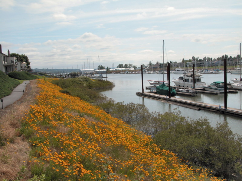
Directions: The trailhead we used is off NW Lake Rd in Camas. One way to get there is to take the 192nd exit from SR 14 to SE 1st St where you will turn right. 1st St turns into NW Lake Lake Rd. Near the bottom of a hill, look for the driveway to the boat launch. The path follows the west shore of the lake.

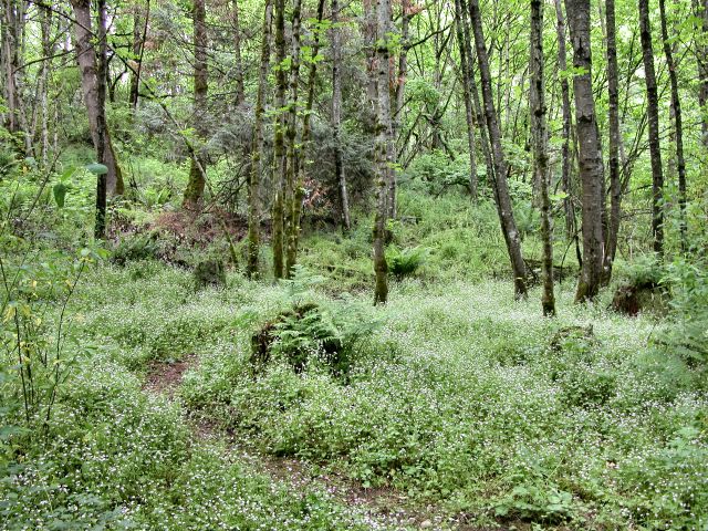
Every time we have been in this area, we have gone to Lacamas Lake Park without ever realizing that this very nice trail was so nearby. On a sunny early-spring day, if it is just a bit cool for the shade of Lacamas Lake Park, give this path a try. Or on a hot summer day, the shade of the deciduous trees is a nice break from the heat.

The path begins over asphalt across the driveway from the restrooms. Feeders at the small home to the left of the path attract juncos, chickadees, towhees and song sparrows, to name a few. In the past, the path appears to have been surrounded by blackberry bushes, but much work has been done to eliminate the nuisance.

After ¼ mile, the path changes to gravel, but strollers and bikes will do fine. On Lacamas Lake in the spring, you might spot scaup, gadwall, pied-bill grebes, American widgeon, bufflehead, double-crested cormorants and geese. You might also stroll down to the shore to see the hundreds of water snail shells, the remains of the meals of many mallards. Salmonberries, Indian Plum (Oemleria cerasiformus) and flowering trees are in bloom as are a few other early wildflowers. Wildflowers continue to bloom into August, including the orange Impatiens capensis.

After about 1.4 miles, you arrive at a boat launch where you must turn left uphill to rejoin the path. Before you do, take a look across the lake to the bright red Leadbetter Mansion.

The surroundings from here have a considerably less wild feel, but if you like to gawk at some gorgeous houses, you are in luck. A few more spots along the way yield some surprising sights. During our spring visit, we saw a large flock of gulls, a mixture of mew, California and ring bills. From one of the bridges, we spotted a great mass of rough-skinned newts in the water. Summer birds may include kingfishers, osprey, goldfinches (especially near the blooming thistle), white crowned sparrows, willow flycatchers and western wood peewees. On a hot, early August day, we saw one patient heron stalking through the marshy area toward the north end of the lake.

After 3.3 miles, the path ends in another parking lot. If you didn't notice before, sunny days yield a great Mt. Hood view on the return trip. Other wildlife we spotted included a garter snake, black and orange caterpillars, red breasted nuthatch, yellow-rumped warblers, winter wren, stellars jays, flickers, a kingfisher, red tail hawk, bushtits, gold-crowned kinglets, house sparrows, robins and signs of beavers. Go see what you can find! Map.

Wednesday, February 28, 2007

NE ~ Portland Neighborhoods


Date visited: February 28, 2007
Agency: Public Streets
Path Surface: Sidewalks
Elevation gain/loss: variable
Distance: You decide
Ratings: Setting varies Calorie-burning varies
Directions: Try the Lloyd Center as a jumping off point

Sometimes, the weather acts as a major deterrent to the desire to set foot out of the house, let alone to actually go for a walk. But even if you can only manage to get as far as your neighborhood, or a neighborhood in another part of the city, you still get the fitness part of the equation with surprising variety.

On those gloomy days when any dirt path is likely to be one big mud pit, the trees will be dripping all over you and the sky is gunmetal gray, we have taken to using a map program to print off a street map of any neighborhood. We then look for the through streets, strap on a pedometer and just walk.

Today, we traveled north from the Lloyd Center and wound a 10k walk through the streets of northeast Portland. We had a very nice walk and enjoyed the character and sense of history in the grand old homes. The one shown above just happens to be a house where my grandfather boarded when he was a young man.

Go as long or as little as you like. You can always find a route back to your starting point. And birds who brave the weather may still give you just that little bit of nature.

Tuesday, June 06, 2006

N ~ Tomahawk Island


Date visited: June 6, 2006. Updated April 30, 2008
Agency: Mainly private property, please respect the rights of the property owners
Path Surface: Sidewalks and asphalt
Elevation gain/loss: none
Distance: 4.4 miles
Ratings: Setting ++ Calorie-burning ++
Directions: From I-5, take the Jantzen Beach exit. The path starts on the east side of the Jantzen Beach Red Lion.

Columbia River views, birds and wildflowers are the highlights of this walk in spring. You will also see enough boats, big and small, to make you wonder if any landlubbers live on the island.

From the east end of the Red Lion parking lot, set off on the sidewalk that parallels the river. Follow the path as it circles Hayden Bay, where boats bound to docks bob in the water. (Please remember that you are on private property and abide by the rules banning bikes, skating and skateboards.) Several varieties of swallows swoop by, blue herons stand stock still on the banks and Canada geese have staked out their claim in the lawn.

Follow this path to its end, walking south to Tomahawk Island Drive and turn east along the tree-lined, shady walk. Watch for large bumps in the asphalt along here, where the trees roots can easily trip you up. Pass the Sexton's Chandlery and turn west on a cul-de-sac that will serve the new Saltpare Bay condos. On the north side of the cul-de-sac is an asphalt path that leads out to a view of, yes, more boats.

Return as you came, but detour if you like into Lotus Island Park, south of Tomahawk Island Dr. for lunch or a snack, where you can sit awhile overlooking the Columbia Slough.

Friday, April 28, 2006

NE ~ Discovery Trail-Leverich to Nicholson


Date visited: February 18, 2006
Agency: Vancouver-Clark Parks & Recreation
Path Surface: Paved
Elevation gain/loss: 30 feet
Distance: 4 miles round trip
Ratings: Setting +++ Calorie-burning +++
Directions: From I-5, take the 39th Ave. exit in Vancouver and turn east. Turn left just before going under the SR 500 overpass onto Leverich Way. Keep to the left to reach the north end of Leverich Park, the third entrance to the right.

This paved path joins three different parks for a pleasant walk or short bike ride. It can also be joined with the Stewart Glen portion of the trail for a longer bike ride. (See December 27, 2005 post.)

From the southeast corner of the parking lot off Leverich Way, enter the path and stay left at all junctions to cross the park. Of course, you can add a bit more mileage if you detour at any intersection in the grassy, well maintained park. Eventually, by heading in a generally southeasterly direction, you will exit the park at 15th St. See

Wednesday, February 22, 2006

NE ~ Johnson Lake


Date visited: February 14, 2006
Agency: Portland Parks & Rec, see also Columbia Slough Watershed Council
Path Surface: dirt, gravel and paved portions
Elevation gain/loss: Minimal
Distance: 3.2 miles
Ratings: Setting ++ Calorie-burning ++
Directions: From I-205 northbound take the Sandy Blvd exit, from southbound, take the
Killingsworth exit (Hwy 30 west). Turn west onto Killingsworth, veer right onto Columbia Blvd, then almost immediately turn right on 92nd Ave. After .25 mile, turn right onto NE Colfax and go to the end of the road.

While an unlikely area for a nature walk, you may be surprised at the waterfowl and grassland bird viewing opportunities here, in spite of the freeway and jet noise. Start on the dirt/gravel path at the end of Colfax. In less than .1 mile, passing through a small forest of cedar, doug fir, black cottonwood and ash trees, we came across a small pond swarming with water fowl--mostly the multi-colored and beautiful wood ducks. Walking just a bit farther brings you to the shore of Johnson Lake. Of the several access points to the lake, really, the clearest view is from Glass Plant Rd. at the east end of the lake. Common mergansers, heron, kingfishers, widgeon and
bufflehead maneuver in and around the water. Song sparrows, red wing blackbirds, robins and scrub jays enjoy the brush and trees nearby.

After about .2 mile, emerge from the trees at a self-storage location. Walk north (left) along Glass Plant Rd. for .1 mile, crossing the Columbia Slough, then turn left on a paved path parallel to the slough. The waters of the slough are often still and lifeless, but some of the surrounding vegetation might produce views of perching birds.

After .5 mile the path turns north along 92nd Ave. When it ends at the sidewalk, cross Alderwood at the crosswalk. The path continues through trees and brush on one side and the wide open fields surrounding the airport on the other. We spotted black capped chickadees, ruby crown kinglets, a flicker, and a Bewick’s wren. Meanwhile, a hawk soared overhead, the light catching the rufous tail for which the bird is named. After 1.35 miles, as the paved path turns back toward the street, turn right on a faint dirt trail that arcs around a small brick building. Try to
stay on the “main” path that crosses the open fields, avoiding the small hidden sloughs, where we spotted several widgeon, to eventually arrive at Cascades Ave. Turn right and follow the sidewalk that borders the vast open field. Rumor has it that pheasants still live in the grass here, along with meadow larks and savannah sparrows. We did not see any of these on this late winter day, but did spot a kestrel and harrier hunting.

Continue on Cascades Ave. as it rolls around to the east. Note the rarely used benches in the median if you need a break. Also take in the view of Rocky Butte to the south. Take the first right, a newly opened and yet unmarked street that returns back to Alderwood. Turn left, returning to Glass Plant Rd., turn right and return to Simpson Rd, re-enter the woods by Johnson Lake and retrace your steps back to your car.

Monday, June 06, 2005

NE~Columbia Springs Environmental Education Center


Date last visited: May 13, 2005
Agency: Various
Path Surface: Paved/Dirt
Elevation gain/loss: 20 feet
Distance: Variable, but up to 3.5
Ratings: Setting + Calorie-burning + +
Directions: I-5 or I 205 to SR14 east to 164th Exit. Turn right from the ramp, then right again on Evergreen Hwy. When the massive structure of I-205 is in sight, watch to the right for visitor parking for the fish hatchery, now called the Columbia Springs Environmental Education Center. GPS N 45.35.976, W 122.32.856

This area is better if you plan to wander rather than looking at it for a workout. Several loop trails provide a natural setting, but the distance (such as it is) parallels Evergreen Hwy. Traffic on the highway is not terribly busy, but train, freeway and street noise combine to make this a less than ideal option for a peaceful undertaking.

From the parking lot, westward, two paved paths branch off. The right path puts you onto a sometimes muddy trail that takes a 1/3 mile loop through the woods. The forest is lush and wet this time of year. After doing that loop, return to the parking lot and take the left paved fork, which, after less than .1 mile, emerges from the woods to right beside the street. Not long after that, another path to the right takes you into the Biddle Nature Preserve for another loop. If this were most anywhere else, this would be a peaceful stroll through the woods, but the constant roar of the freeway traffic reminds you of where you are. The typical suburban birds flit about: we saw starlings, house sparrows, robins, towhees and song sparrows.

Continue west on the paved path after exiting the preserve. The path opens to a neighborhood, but you might still spy a redwing blackbird or two. After crossing the highway, you might catch a glimpse of the Columbia River, and an occasional osprey circles overhead. At Ellsworth Rd, .7 miles west of the preserve, we turned left and walked down to the railroad tracks for our return trip. There is plenty of room to walk, but be sure to watch for trains because this track is in use. Here, a few rabbits hopped ahead of us. We also saw crows, rock doves and gold-crown sparrows. Return to the highway along a driveway that is not gated.

After returning to the parking lot once again, take the time to wander through the hatchery area. A few more short trails to the east of the hatchery also provide interesting viewing, including, several wood ducks and on this day, an angry blue heron that could not figure out why it could not get to the fish in the large pond! (You'll see.) Map of area. Posted by Hello

Tuesday, December 07, 2004

NE~Washougal Dike/Steigerwald Lake


Date last visited: December 8, 2004
Agency: Port of Camas/Washougal
Path Surface: Gravel- vehicle wide
Elevation gain/loss: minimal
Distance: 3.5 miles one way

Ratings: Setting +++ Calorie-burning +++
Directions: East of Vancouver on State Route 14, to Washougal. Right (south) off the highway at 15th to Steamboat Landing. GPS 45 34.568N, 122 22.698W

This wide trail on top of the Washougal Dike parallels the Columbia. During the first part of the walk, you will want to look south, unless you are fascinated by all things mechanical. The man-made vista can be mitigated by looping to the south on the floating walkway at Steamboat Landing. Look for the interpretative signs as you come back up onto the viewing platform.


Continue east after returning to the top of the dike. The views of the river are especially good now with less foliage on the trees.

At 32nd St., we walked down to Cottonwood Beach, where Lewis and Clark camped for six days in March and April of 1806. We didn't return this way, but it looks like you can continue east on the beach and loop back up to the dike at 35th St.

Consistent with Washougal's location at the edge of suburbia, the trail from this point east become increasingly rural. Passing by the last of the factories and a train switching area on the left, the trail edges an immense open field where we observed both a red tail and a harrier hunting. At about a mile and a half from 32nd St., we stopped to watch hundreds of lesser scaup fly from a pond in the Steigerwald Lake National Wildlife Refuge across the path to the river. The whisper of a thousand wings overhead made the whole walk worthwhile.


We also saw bufflehead, mallards, Canada Geese, a kestrel, flicker, downy woodpecker, and ruby-crowned kinglet along with house finches and chickadees. We had reports of sightings of deer, fox and coyote at dusk.

The open portion of the trail ends just as you reach Steigerwald Lake, off in the distance to the north. Map.
October 2006 update: Interpretive and directional signs, plus a new viewing platform have been added to this trail.
Posted by Hello