Here's a resource that I just discovered for trails in the West Linn area. I haven't been on any of these trails except some in Mary S. Young park, but as I get there, I will post reviews.
Trail Maps for the City of West Linn
Showing posts with label Southeast. Show all posts
Showing posts with label Southeast. Show all posts
Thursday, May 29, 2014


Monday, November 29, 2010
SE ~ Powell Butte

Date visited: November 10, 2010
Agency: Portland Parks and Recreation
Path Surface: Some pavement, but mostly dirt
Elevation gain/loss: 300 ft
Distance: Variable and can include mileage on the Springwater Corridor.
Ratings: Setting +++ Calorie-burning ++++
Directions: East on Powell Blvd to 162nd Ave. Turn right and drive up the hill to a parking area.
On a clear day, not many places can beat the views at Powell Butte. Even on a cloudy day, little windows of opportunity can open. When we first got out of the car, we could see sunbeams on the snow-dusted foothills across the river in Washington. And it's a good place to see a microcosm of northwest Oregon, even on the wet weather days, in the open meadows and forested trails of this park.
The worst thing about Powell Butte is how easy it is to get lost; well, not lost really, but momentarily displaced. Some trails are marked, some trails are a mystery. We had two maps with us, neither of which was entirely accurate. One is shown here, but we had to backtrack on the Elderberry Trail to find our way to the outer loop of the park (or maybe we just can't read a map!) We ended up walking around 5 miles because of our backtracking, but anyone into higher miles can simply drop down to the Springwater Corridor.
I ate a late season blackberry which tasted like thick water, and we noticed some stinging nettle, especially on the south side of the park. But there's plenty of opportunity for bird life.
 Today our bird list included: song sparrows, mourning doves, flickers, three kestrels visible at once, crows, Bewick's and Pacific Wren, Stellar's jay, spotted towhee, a screeching red tail hawk, varied thrush, scrub jay, juncos, golden-crowned kinglets, and finally, a northern harrier cruising the area east of the Orchard Loop Trail.
Wednesday, May 13, 2009
SE ~ Mount Tabor Update

The green trail is up! See previous post here. On our previous visit, the green trail was under construction. The trail marker posts are up now, for this round the butte route. We discovered the new markers too late to measure the distance of the new trail, but we will update this post with that information at a later date.
Friday, March 27, 2009
SE ~ Mount Tabor

Date visited: March 24, 2009, bird species count-- 20
Agency: Portland Parks and Recreation
Path Surface: Gravel, dirt and pavement
Elevation gain/loss: 200 feet
Distance: Three miles as described
Ratings: Setting +++ Calorie-burning ++++
Directions: From SE 60th Ave. in southeast Portland, turn east off SE Salmon St. Turn left at Mt. Tabor Park Road to the first parking lot, across from picnic area A. On Wednesdays when the park is closed to vehicles, follow Belmont to turn south on SE 69th for parking near the entrance.
One of the eastside buttes, Tabor is a multi-use and lovely city park. Expect many people (and dogs) on most every day.
Trails crisscross through the park, but the Friends of Mt Tabor Park have marked some routes for nice overviews of all the park has to offer. This trail guide was available (today) at the kiosk at the edge of the parking lot. We took the “Blue Trail,” which involves some climbing, stairs and, right now, circling around construction.
Start out down the road to the right from the kiosk 50 yards until you see a blue topped post. Turn downhill onto the footpath here. Turns and intersections are marked with these posts, and some blue arrows stuck in various places here and there. Although the trail is marked, the trail guide is helpful for detours, like the current construction area near Reservoir 5. You'll see woodsy and open areas, reservior views and wonderful Portland skyline shots. A few wildflowers are blooming even now; undoubtedly more to come.
The park is closed to all public vehicle traffic on Wednesdays, but it's only a hop, skip and jump to the entrance from your car on 69th St. The absence of most vehicles (maintenance trucks rumble through) makes the park all the better. Morning bird song walks take place here on Wednesday during the spring as well.
Trail map without the Friends' route highlighting.
Friday, January 16, 2009
SE ~ Reed College: The Canyon

Date visited: January 12, 2009
Agency: Reed College
Path Surface: Dirt (muddy today), some wood chipped sections
Elevation gain/loss: 40 feet
Distance: 1.75 round trip as described
Ratings: Setting +++ Calorie-burning ++
Directions: Go north from Woodstock or south from Holgate on SE 28th Ave in southeast Portland. Parking at Crystal Springs Rhododendron Garden or on campus off of SE 28th.
Combine this walk with Crystal Springs Rhododendron Garden and you will be surprised what hidden treasures lie between city streets in these two areas.
From the Garden, cross SE 28th Ave, follow the sidewalk into the campus parking lots (or start from the parking lot), keeping the tennis courts on left. Walk toward the theater building and turn left on the sidewalk in front of the theater (on Botsford Drive). Walk down hill about 50 yards and look for steps down the bank to a trail. On the trail, head back toward the theater building on the boardwalk and continue under its edge, following Crystal Springs Creek. Continue on the trail past the waterfall which should be to your right. When you reach pavement, jog slightly right and continue on the dirt trail.
Soon you are in fine view of the lake, where winter waterfowl paddle and dive. Common snowberry (Symphoricarpos albus) glows brightly white in contrast to the gray day. Continue eastward, ignoring all side trails. At the far end of the lake, bare branches fan out over the marsh, rife with perching birds. We saw three species of woodpeckers and many kinglets, both ruby-crowned and golden-crowned. Round the loop to head back westward, again staying with the main trail. At a maintenance parking area, turn right to walk across the dam and then left to retrace your steps on the dirt path along the creek.
We listed 24 species of birds on our walk today.
Aerial view.
Wednesday, November 26, 2008
SE ~ Crystal Springs Rhododendron Garden

Date visited: November 24, 2008
Agency: Portland Parks and Recreation
Path Surface: Paved and pea gravel
Path Surface: Paved and pea gravel
Elevation gain/loss: 30-50 feet
Distance: Variable, up to 1.5 miles by walking the perimeter and many criss-crossing and side trails, more mileage by crossing to Reed College Campus
Ratings: Setting ++++ Calorie-burning +
Directions: The parking lot is near the intersection of SE 28th and Woodstock in southeast Portland. GPS N 45.48003, W 122.63529
NOTE: ADMISSION CHARGED IN THE SPRING/SUMMER EXCEPT ON TUESDAY AND WEDNESDAY
NOTE: ADMISSION CHARGED IN THE SPRING/SUMMER EXCEPT ON TUESDAY AND WEDNESDAY
Why would you want to go to a rhododendron garden in fall or winter? For the birds, of course. Yes, there are too many mallards to count, but also some surprisingly good waterfowl views—evidently due to the rampant feeding that goes on by visitors. The normally timid wood ducks will actually pose for pictures!
 The honking of Canada geese can overpower the rumble of the nearby trains. Paths may get busy and clogged on a nice day, but remember, calorie burning is all about distance and not time.
Even if you don't stop to look at the birds, this is a lovely place in its own right. Waterfalls, a clear water lake and a beautiful wooden bridge are just a few of the features unspoiled by the fact that only a very few flowers were blooming on this mid-fall day (none of them rhodies). If this isn't enough mileage for you, just cross the street from the parking lot and you can get more mileage in Reed College Canyon.
Saturday, August 02, 2008
SE ~ Kelly Butte Natural Area

Date visited: July 31, 2008
Agency: Portland Parks and Recreation
Path Surface: Dirt
Elevation gain/loss: 60 feet
Distance: 2 miles
Ratings: Setting + Calorie-burning ++
Directions: Division St east from I-205. Turn south on SE 103rd Ave. to small gravel turnout at gate.
This place is overgrown and a bit creepy, and that was even before I read here. If you are close and want a two mile walk with some elevation and views, give it a try. Otherwise, skip it and head farther south to the much better maintained Mount Talbert.
We took the following route: After parking in the small pullout with two other vehicles, we launched over the bars beside the gate—made me wonder right then if we were really welcome in the park. We walked the road up the hill under maples and alders, with some view to the north. So far, so good-- then we turned right into what looked like another parking area with another couple of gates and a very deserted and derelict feel to it. We headed across the pavement to a graveled area and continued on a dirt trail right in front of us.
Into the woods--good-- things will get better. Kind of. We walked up the hill on the trail to a T intersection and turned left. The trail is fairly level for a bit, in very nice woods, then starts downhill, with some nice views along the way. We tried left at a fork, only to be attacked by killer blackberry thorns. We walked back to the intersection and tried the right fork. This took us further down hill on an overgrown path. At least there were a few ripe thimbleberries to reward our efforts. At the bottom of the hill is a huge water tank. We walked all the way around it to view the “art.” This area is level and grassy: head here if you are the picnic type.
We then walked by an unidentified brick building to the south (visible from the water tank) onto another dirt path, clawing through the overgrowth, past an area which shows evidence of camping. We then turned right to circle back to the path leading to the water tank, turned right, passed the thimbleberry patch again, then left to head back up the hill. We stayed on this path up over the top and it eventually led to a grassy bank above the paved parking area we walked through earlier. We turned back down the road to our car.
We saw not another soul while we were there. The good news is that there are a few places with wildflowers and we saw some bird activity, including Stellar's jays, chickadees and bushtits. We did not see the bomb shelter.
Tuesday, April 29, 2008
SE ~ Mount Talbert

Date visited: April 29, 2008 and August 18, 2010
Agency: Metro
Path Surface: Dirt trail, some gravel, roots, rock and mud in the trail in some areas in winter and spring
Elevation gain/loss: 350 feet
Distance: 4.2 miles of looping trails
Ratings: Setting +++ Calorie-burning ++++
Directions: I-205 to Sunnybrook Road. South on 97th until it becomes Mather Rd. Look for the low sign marking the park on the left. 10695 SE Mather Rd.
Notes: Because this is a Metro property. NO DOGS are allowed in the park.
Be forewarned that the Park Loop Trail is not "officially" a loop. A portion of the loop is "closed." However, the only evidence seen of the trail closure on our August 2010 visit is a sign on the east side, but we saw several people on the well-worn trail.
Trail map (does not show the portion of the Park Loop Trail that is allegedly closed)
Trail map (does not show the portion of the Park Loop Trail that is allegedly closed)
The Portland area was not always the calm, serene place it is now—at least geologically speaking. Here and there, volcanic buttes jump out of the surrounding plains. One of these, Mount Talbert, is the site of a new Metro park.
Though surrounded by houses, apartment complexes and roads, the park is amazingly unspoiled. We saw no ivy and many native plants. A very nice attribute is the oak savanna on the West Ridge Trail. Other features of the park include a prairie loop (though it doesn't look like much now), interpretive signs and a covered picnic area. Posts at each trail junction guide your path to the top, but those hiking to the summit might be disappointed by the lack of a view.
Our “nature report” for our April visit includes: birds - Cooper's Hawk, Downy Woodpecker, Steller's Jay, Black-capped Chickadee, Red-breasted Nuthatch, Bewick's Wren, Winter Wren, American Robin, Orange-crowned Warbler, Nashville Warbler, Yellow-rumped Warbler (Audubon's), Townsend's Warbler, Western Tanager, Spotted Towhee, Song Sparrow, Dark-eyed Junco (Oregon), Purple Finch, Pine Siskin, Lesser Goldfinch; and flowers in bloom - Ethrythronium oreganum (fawn lily), Camassia quamash (camas), Cardmine nuttallii (oaks toothwart), Viola glabella (stream violet), and Synthyris reniformis (deer flower). Also of note: POISON OAK AND STINGING NETTLE near the trail!
In August, the bird activity is considerably less. Some wildflowers are still blooming.
Tuesday, October 23, 2007
SE ~ Gresham Butte Saddle Trail

Date visited: October 17, 2007
Agency: City of Gresham
Path Surface: Gravel
Elevation gain/loss: 200 feet
Distance: 2.6 miles
Ratings: Setting ++ Calorie-burning +++
Directions: Access from either end of the trail. From Powell Blvd, turn south on Towle Avenue or Regner Rd. Parking on the street is available on either end—at Southwest 19th Drive off Towle Avenue or Southeast 19th Drive off Regner Road.
Fall is a great time to take this trail because of the abundance of deciduous trees. Formerly an old logging road, the trail traverses the saddle between Gresham and Towle Buttes and Gabbert Hill. Pretty much a straight shot through the woods, go out and back for the full mileage, and expect some climbing. In addition to the hills, there's plenty of room to roam the neighborhood streets surrounding the trail for some additional calorie expenditure. There appears to be other trails that branch off from the main trail—we did not take them, but will explore another day. The Springwater Corridor path is also nearby.
Map (page 2 of the document)
Friday, June 22, 2007
SE ~ Springwater Corridor

Date visited: June 19, 2007
Agency: Portland Parks & Recreation
Path Surface: Paved until Rugg Road
Elevation gain/loss: very slight upward grade going eastbound
Distance: 21+ miles
Ratings: Setting ++++ Calorie-burning ++++
Directions: Several access points (see map link at end), described below is access from Max.
The premier paved path of Portland, developed on the old Springwater Line railroad way, provides distance, variety and surprisingly wild areas right in the city. To see it all, take your bike, but certainly, pedestrians will enjoy the path as well.
Exit Max at the Yamhill or Morrison stops closest to the river. Cross to Waterfront Park and head south along the river. Find the eastbound entrance to the Hawthorne bridge by riding under the bridge, then veering right onto a ramp up to bridge level. After crossing the bridge, continue south as far as possible on the pedestrian/bike path (passing OMSI), then turn left onto the street (Carruthers), then take a right on 4th (look for the small Springwater Corridor directional sign). Continue on 4th for two blocks and you will see the path ahead of you. After passing noisy Ross Island Sand and Gravel, you will find yourself in a different world.
From this point to the path's current end just past Oaks Bottom is frankly my favorite part. River views, deep woods and a high bank to the east let you imagine you are miles from the city. Oaks Bottom Wildlife Refuge is a real treat for birding, whether you detour into the Refuge proper or just pass by on the way. If you just want a 10 mile out and back, this section is for you.
When the path reaches its current end, a detour on quiet streets will bring you to the remainder and majority of the trail that goes all the way to Boring. Turn left off the path at its end onto Umatilla St. Follow it east to SE 19th, turn right and ride straight into the continuation of the path (these turns are signed). This section incorporates the “Three Bridges,” a fairly recent and most useful addition, spanning previously difficult crossings.
From here, mileage and variety are yours. The path passes through woodsy areas, parks, fields, farms, historical sights, Mt Hood views and not very much roadside. Covered benches are placed along the way if you want to take a breather. The paved portion ends east of Gresham, but hardy riders can travel the entire 21 plus miles to Boring.
For more information about the path and its history, click here.
Tuesday, October 31, 2006
SE ~ Laurelhurst Park to Lone Fir Cemetery

Date visited: October 27, 2006
Agency: City of Portland and Metro
Path Surface: Paved with one small stretch of gravel
Elevation gain/loss: minimal
Distance: Four or more miles round trip
Ratings: Setting: ++ Calorie-burning ++
Directions: Laurelhurst Park, I-84 to NE 39th St exit, turn south on 39th to SE Oak. Turn right to
park.
Try this out as a perfect warmup to get you in the mood for Halloween.
Begin at Laurelhurst Park, and circle the perimeter of the park on the wide paved path. Feel free to wander the park for a bit of extra mileage and scenery. Especially inviting to view is the spring-fed pond, where, if you are lucky, an amazing assortment of water birds drop by. Sometimes, though, you may not want to approach the pond water, because, in spite of efforts to clean it up, this pond sees a lot of abuse, both human and wild. Around the edge of the tree-filled park, you’ll see and hear a variety of birds you may not expect in the middle of the city.
After enjoying the park, walk south to SE Stark St. (A complete circuit of the perimeter of the park is almost 1 mile.) Turn right on Stark, or wander the adjoining neighborhoods in a westerly direction to avoid Stark Street’s traffic noise. At SE 26th, turn left (south) passing by the east edge of
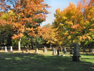
The cemetery was named for the lone fir on site in 1866. Walk the .8 mile perimeter of the cemetery for a stunning display of fall colors in the variety of trees there now. Though you can simply complete your circuit of the grounds, it is difficult not to be pulled in by the historical significance of the those laid to rest here (Curry, Dekum, Hawthorne, Lane, Lovejoy, Macleay)and the unique and beautiful headstones. More than 25,000 people are buried in the cemetery.
Wander back to your car by heading east, although you may want to detour a few blocks to the south to take at look at the church tower and stained glass windows of the Hinson Baptist Church at SE 20th and Salmon. Congratulations, you've burned enough calories to eat a Halloween-sized candy bar!
Tuesday, December 27, 2005
SE ~ Oaks Bottom
Date visited: December 16, 2005
Agency: Portland Parks & Recreation http://www.portlandonline.com/parks/?c=35300
Path Surface: Dirt, paved, gravel
Elevation gain/loss: Approximately 150 ft.
Distance: Two mile loop
Ratings: Setting +++ Calorie-burning ++
Directions: From SE Tacoma St, turn north on SE 7th to the parking lot at Sellwood Park.
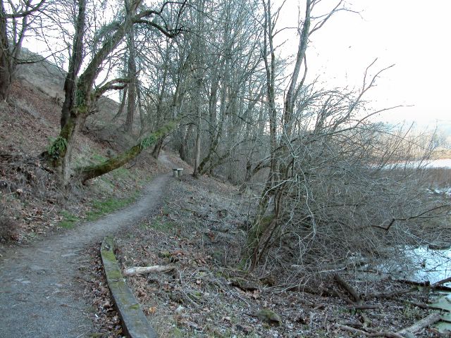
We are fortunate to have what is left of this Willamette River flood plain. Construction of the railroad tracks between the river and bottom lands was the first insult, compounded by garbage dumping and fill from freeway construction, the sum of which nearly obliterated what has become one of the premier preserves of Portland.
From the parking lot, zigzag down the bluff toward the water. Bufflehead and common mergansers dive and surface there. From force of habit, we normally continue along the bottom of the bluff (generally north), passing the wetlands on our left. We had ideal conditions for waterfowl observation today, as ice covered much of the shallow water, causing green wing teal, northern pintail, mallards and a few coots to congregate near the trail where the water was still liquid. Circling among these was a male and female wood duck and one lonely pied-billed grebe. While we watched, a first-year Cooper's Hawk tried without success to take a meal from the suddenly excited flock.
Continuing north along the path shows subtle changes to the vegetation as drier conditions prevail. At .8 mile, shortly after crossing a wooden bridge, turn left (west) on the dirt trail toward the Willamette, or continue just a bit farther north if you prefer pavement, again turning left toward the Willamette. After emerging from the woods, continue left (south) to go under the railroad tracks to the Springwater Corridor path. Step across the path (watch out for bikes) to see the "Shifting Assets" exhibit and get a good view of the river. To complete the loop, follow the paved Springwater Corridor south. Near the entrance to Oaks Amusement Park, the pavement splits. Veer right, downhill, to again pass under the tracks. Follow the gravel trail further south until it swings back to the bluff, turn left along the bluff trail and climb up to return to the parking lot.
A great place to look for birds any time of year--if you have your binoculars, this may the slowest two miles you have ever walked. Other birds on our list today included a downy woodpecker, black-capped chickadees, song sparrows, blue heron, a flicker, golden-crown sparrows, robins, a ruby-crowned kinglet, a brown creeper and a hermit thrush. (November 20, 2007 update to our bird species list: Anna's hummingbird, ring-neck ducks, lesser scaup, Stellar's and scrub jays, robin, flicker, juncos, northern shovelers, mallards, American goldfinch, American and Eurasian wigeon, gold-crowned kinglet, glaucous-winged gull, northern pintail, female golden eye, redwing blackbird, gadwall, ruddy duck, bald eagle, kingfisher, double crested cormorants, crow, hairy woodpecker, Bewick's wren, winter wren.)

Tuesday, March 15, 2005
SW/SE ~ Downtown Bridges Loop
Date last visited: March 4, 2005
Path Surface: Paved and Metal Grid
Elevation gain/loss: 40 feet
Distance: 3 miles
Ratings: Setting+++ (noise detracts from an otherwise higher rating) Calorie-burning ++
Directions: Downtown, from the Max Light Rail, Yamhill District Stop (eastbound) or Third & Morrison (westbound)
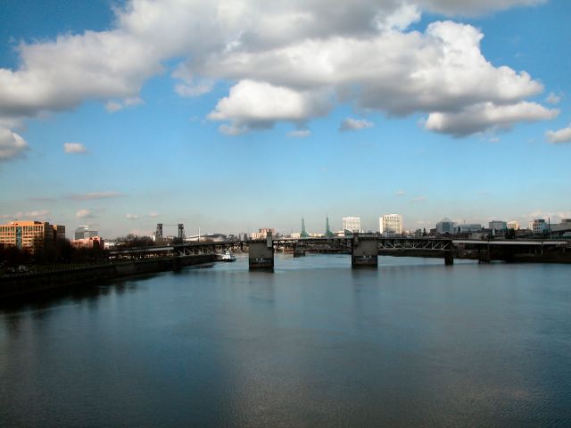
Wildlife, river views, art, parks, a museum and memorials--the essence of downtown in three miles!
The best way to begin your sightseeing is a ride on Max (plenty of "wildlife" on a typical day). From the stops identified above, walk east to Waterfront Park. At Yamhill, the sidewalk crosses the sometimes grassy, sometimes dusty width of the park to the seawall at river's edge. Turn right and walk south, veering right at the Salmon Street Springs to walk in front of McCalls Restaurant, then up the pedestrian ramp onto the Hawthorne Bridge. No promises, but on our walk we saw one of Portland's resident peregrines while we were crossing the bridge. At the east end of the bridge, continue forward until you can turn left, which will drop you down to the "Vera Katz Eastbank Esplanade." Turn north, but pause to look over the stone representation of the Willamette River, next to the PFD building. A dock here takes you right down to the Willamette, but if you have kids with you, you'll get the same close encounter later on with the added benefit of railings.
Continuing north, look for gulls, geese, pigeons, blue herons and double crested cormorants. Get in touch with your right brain as you pass works of art. You might also enjoy reading the brief history lessons posted along the way. At the sign for SE Ash, veer left to drop down to river level. Didn't think you could walk on water?
At the Steel Bridge, cross back over the Willamette, where ships and tall masted boats can cause a brief delay in your journey. At the west end of the bridge, back in Waterfront Park, walk south to enjoy the Japanese Memorial, the Oregon Maritime Museum and Battleship Oregon Memorial Park. Passing the Four Points Hotel to the west across Front, turn right (west) at the green ship's cleat #35 to return to Yamhill and back to the train. With the extra credit for walking to and from the train, you've just done three miles. Map.

Subscribe to:
Posts (Atom)

 Posts
Posts


