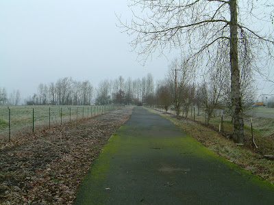

Date visited: January 16, 2007
Agency: City of Vancouver
Path Surface: Paved, 12 feet wide
Elevation gain/loss: None
Distance: Variable, but up to 7.4 miles on paved path or more on trails
Ratings: Setting +++ Calorie-burning ++++
Directions: From I-5, take the Fourth Plain exit and follow it west until it turns into Lower River Rd. To reach Vancouver Lake Park, at a fork, stay right traveling a short distance on Reiger Hwy. To reach the other access points, bear left at the fork.
Two parks, two bodies of water and copious bird life: this is a great trail for walking or biking with several access points to pick just the distance you want to travel.
Vancouver Lake is at the east end of the path and you can begin your trip at this end by entering Vancouver Lake Park off Reiger Hwy. Park as far north as possible in the park and look for the paved path between you and the lake. Walk to the north end, then turn south with views of the lake to your left. From here, follow the path until you turn west, cross the highway and continue west, first along side an open field, where sparrows and great blue heron hang out. After crossing Lower River Rd., the path travels along a slough, where waterfowl skid across the water.
After 1.8 miles, you reach another access point at Blurock Landing. A small parking area here makes this a possible start for a shorter walk to either Vancouver Lake or Frenchmans Bar Park. As you round the corner after passing the parking area, be sure to veer left to take a look at the viewpoint and interpretive sign.
Continuing on the main path northward, your route takes you between the road and another field 1.4 miles to Frenchmans Bar Park. In the park, the trail rises slightly to a view of the Columbia River and Sauvie Island on the opposite shore. Continue following the paved trail south to a viewpoint where you can learn about the Frenchman for whom this park was named. Return to your start point, enjoying the flyby of the many birds along the way.
If you want to tack on just a bit more mileage, two unpaved trails, one in either park, can add just about a mile and a half to your route. See map.
Note for bicyclists: Lower River Road is nearly level and has wide shoulders for some additional mileage out to this path.


No comments:
Post a Comment